Call us: 07878.874.680 | 02392.851.723

Call us: 07878.874.680 | 02392.851.723

Sally Antiques Sally Antiques
  • Home
  • Shop
  • News and Announcements
  • Search
Login / Register
0 Wishlist
0 items / £0.00
Menu
Sally Antiques Sally Antiques
0 items / £0.00
Sold out
Click to enlarge
HomeNautical and MaritimeNavigation Instruments Weems And Plath Navigation Map Magnifier

Weems And Plath Navigation Map Magnifier

SKU: JA_7375140012* (ref. no.)

Out of stock

Add to wishlist
SKU: JA_7375140012* Category: Navigation Instruments Tags: Magnifier, Map, Navigation, Weems And Plath
  • Description
  • Shipping & Delivery
  • Product QR
Description

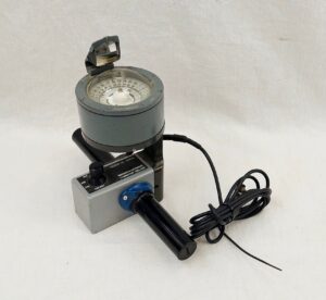
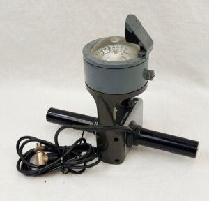
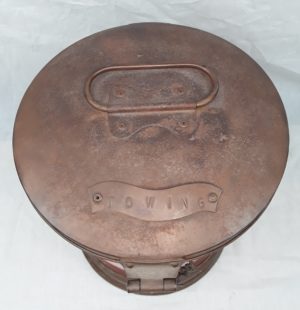
 ~ Weems And Plath Navigation Map Magnifier ~

This magnifier is the perfect aid in reading small print on charts, maps, and documents of any kind.

~ Condition ~

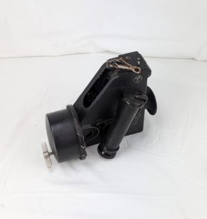
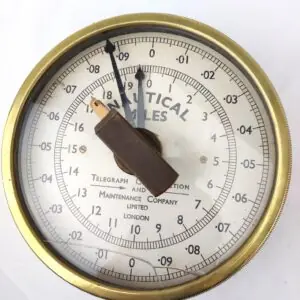
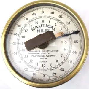
Please refer to the images for the condition.

~ Dimensions ~

The box size is 5 inches (12.5 cm) square, the magnifier is 3 inches (7.5 cm) inches in diameter.

JA_7375140012

Shipping & Delivery
Product QR
Download QRPrint QR

Related products

Close

Brookes And Gatehouse Heron DF Aerial Marine Navigation Compass

£60.00
~ Brookes And Gatehouse Heron DF Aerial Marine Navigation Compass ~ The compass was made by Brookes and Gatehoue of
Add to wishlist
Add to cart
Close

Ships Mechanical Control Cabin Clinometer Eiwa Seiki Co Ltd - Japan Osaka

£150.00
Eiwa Seiki 20th century Ships Inclinometer
Add to wishlist
Add to cart
Close

Original WW2 Marseille – Nice Army/Air Style War Office Map No. 2758

£40.00
~ Original WW2 Marseille – Nice Army/Air Style War Office Map No. 2758 ~ An original Second World War Map
Add to wishlist
Add to cart
Close

WW2 1944 Cased Henry Hughes & Son Husun Royal Navy Submarine Sextant In Bakelite Case

£595.00
~ WW2 1944 Cased Henry Hughes & Son Husun Royal Navy Submarine Sextant ~ ~ In Bakelite Case ~ A
Add to wishlist
Add to cart
Close

Ships Towing Lantern by Seahorse #2

£225.00
~ Ships Towing Lantern by Seahorse #2 ~ A ships towing lantern by Seahorse of Great Britain The lantern is
Add to wishlist
Add to cart
Close

1930s Hamburg Amerika Line Map Of Norway

£40.00
~ 1930s Hamburg Amerika Line Map Of Norway ~ ~ Condition ~ Please refer to the images for condition. It
Add to wishlist
Add to cart
Close

Air Ministry WW2 Bubble Sextant Mk 1XA Dated 1943

£195.00
The bubble sextant is a specialized device used to measure the angles between celestial objects, such as the sun, moon,
Add to wishlist
Add to cart
Close

British, Brass Nautical Miles Gauge, Telegraph Construction and Maintenance Company Limited, London

£275.00
*British, Brass Nautical Miles Gauge, Telegraph Construction and Maintenance Company Limited, London* Approximate measurements: 19cm diameter x 7cm depth The
Add to wishlist
Add to cart
  • Legal Disclosure
  • Privacy Policy
  • Terms & Conditions
  • Return Policy
  • Search
Copyright © 2020 Jolly Antiques - All Rights Reserved.

You can visit our shop at the Sally Port Inn,
57-58 High Street, Old Portsmouth,
PO1 2LU, Hampshire, UK.

We are open for business
7 Days between 10am and 5.30pm.

SallyAntiques is part of JollyAntiques.co.uk Antiques Marketplace
  • Menu
  • Categories
  • Home
  • Shop
  • News and Announcements
  • Search
  • Wishlist
  • Login / Register

Shopping cart

close

Get in Touch

Loading…
Shop
0 Wishlist
0 items Cart
My account

Sign in

close

Lost your password?

No account yet?

Create an Account